
The South-West Suffolk Echo reported that from their records
the flooding in 1958 was probably worse than in 1903. In 1903 the water
reached Attertons gates, but this time it penetrated the works of that
firm now called Atterton and Ellis. A photograph of the local policeman,
PC Saunders on patrol wading through the floods at the Crowland Road and
Withersfield Road junction was published in the Haverhill Echo. It made
the front pages of some national newspapers.
Passengers getting off the morning train at Haverhill were stranded because
Station Road and Wratting Road were impassable.
By late Friday afternoon the floods had moved away, and traffic could
pass through Haverhill once again. But the water had only moved down the
Stour valley to flood Clare, and Sturmer village.
In the aftermath people were warned to boil their drinking water. The Haverhill Fire Brigade were supported by firemen from Gurteens, and the Westgate Brewery in Bury also sent one of its fire engines to help pump out flooded cellars Friday and all through Saturday. RAF Stradishall sent special heaters to dry out premises. Newman and Co advertised 10% off paints and decorating materials for a period of one month to assist victims of the flooding.
A succession of minor floods over the following decades
showed that the town needed proper flood defences that could cope with
a possible overflow of the local rivers and streams. So in 1971 and 1972
one of the unsung saviours of the town's inhabitants was constructed in
the form of the Meldham Washland.
Most people probably know it as the Flood/West Town Park, a 48-acre area
of land adjacent to the main road – a stone's throw from Sainsbury's
retail park.
The Washland is a flood storage reservoir situated at the confluence of
Spring Grove Brook, Stour Brook and Hanchet End Brook and can store up
to 76 million gallons of water. On average is it expected to fill to the
top once every 400 years.
The Washland was created at a cost of £253,000, and its impact has been significant. The Washland has come into play twice, during the October 1987 hurricane, when it half-filled with flood water and in October 2001 when the average monthly rainfall fell in 24 hours.
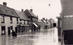
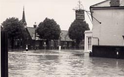
50 YEARS AGO: THE HAVERHILL FLOOD
Queen Street (Left) and Cangle Junction (below) during the great flood.
The flood storage reservoir has proved to be a big success for the town. If it had not been there then Haverhill would have been badly flooded in 2001 when the reservoir came close to being full. This demonstrated just how much water was diverted from the town and its houses.
Water storage is formed by an embankment up to 18ft high at the easterly end of the site which extends west alongside the main road and also alongside the incoming Stour Brook. Once the flows in the brook entering the washland reach a certain level they spill over the river bank onto the washland, which then slowly fills up. The water is allowed to escape back into the brook very slowly through something called an outlet control structure. The amount escaping is considerably less than the amount coming in so the flows reaching the town centre can be carried safely away.
This is good news for the residents of Haverhill who can sleep easy knowing that even if the 50 year flood does come again the flood defences will save the town.
50 years ago a major rainstorm flooded Haverhill. This was not the first time the town had been flooded because almost exactly 50 years before that in 1903 the town was also flooded by torrential rain. Is Haverhill ready for another deluge?
In June 1958 a terrible storm struck Haverhill. Most of
the High Street and Queen Street area of the town, including the Pightle,
was flooded. From Friday 20th June to Friday 27th June, some 3.89 inches
of rain fell. Thursday 26th June was quite a dry day, but overnight there
was a downpour, and about 1.7 inches of the week's total fell in that
night.
People woke up on Friday the 27th to find their homes flooded. These were
the worst floods in Haverhill for fifty-five years since those in 1903.
From the Co-Op to the Plough Inn in Withersfield Road, the water was up
to four feet deep. No main road out of town remained open and most villages
around were also flooded.