
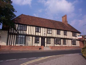
Anne of Cleeves House
A brief history of HAVERHILL
(or Haverhill through the ages)
Original research and text by Michael Horne (c) 1999
Unfortunately many of the great buildings were destroyed by a fire in 1667 and continuing improvements and modernisations over the last three centuries have taken their toll. However there are still clues, such as Anne of Cleeves house and the Queen’s head pub that indicate the rich history of Haverhill’s past.
Haverhill has a rich history and probably dates back to
pre-Roman times, as indicated by Iron age artefacts discovered in the
area.
During the Roman occupation there was almost certainly a battle near Sturmer
in AD60 between the ninth Roman legion, and the British forces composed
of the Iceni and the Trinovantes (originally under the command Queen Boudicca).
In the next three centuries, Roman villas and other settlements flourished
at Castle Camps, Haverhill, Ridgewell and Wixoe, and a Roman cemetery
was discovered at Withersfield in the eighteenth century. The River Stour
was apparently navigable as far as Wixoe, and the main road through Cambridge,
the Via Devana which originated in Chester, definitely went as far as
Withersfield, and may have gone on through Haverhill to Colchester.
After the Roman's departure in 410, the history of Haverhill is obscure
for the next 500 years, though many theories have been advanced, usually
with little credibility. It was not until the time of the Doomsday Book
(1086) that Haverhill had established itself as a market town and by the
twelfth century there were manors at Haverhill, Horsham and Hanchett,
and possibly a castle, although no direct evidence of this building until
1373, it may well have been merely a fortified manor house rather than
a fully-fledged military establishment.
From 1008 onwards, for administrative purposes, most of the town was in
the Risbridge Hundred of Suffolk, but one third of it was in what is now
the Hamlet Road area, in what was called the Hinckford Hundred of Essex.
This curious split continued for almost nine hundred years, until the
end of the nineteenth century, and explains why Hamlet, even today, is
very different in character from the High Street. Now, of course, the
whole of Haverhill is in Suffolk.
During the later Middle Ages, Haverhill prospered, and was
featured prominently on 14th and 16th century maps of England, much more
so than some of its neighbours like Linton, Clare and Sudbury. Records
of the market in the reigns of Henry V and henry VI (1431-1461) give evidence
of a significant trading centre, with shops and stalls selling meat, fish,
cloth, small goods, lace etc., and traders coming in from places like
Hundon and Steeple Bumpstead. Haverhill was also a minor centre of the
woollen industry and became a weaving town, a characteristic it maintained
for several centuries.
In the sixteenth century the town continued to flourish. It obtained a
royal connection on January 27th 1541, when the parsonage, lands and right
to appoint clergy were granted to Henry VIII’s fourth, and recently
divorced wife Anne of Cleves. A further royal connection came when Queen
Elizabeth passed through Haverhill in 1568, on her way from Horseheath
Hall to Kedington Hall. By 1620, Haverhill had become well known as a
Puritan town. It produced many leading Puritan preachers such as the Ward
family (John, his sons Samuel and Nathaniel and his grandson John). the
Faircloughs and the Scanderets. There were several emigrations to America,
where Haverhill Massachusetts, was founded in 1640. The Barnardistons
of Kedington were leading officers in Cromwell's army, and the whole area
supported Parliament against the King in the Civil Wars.
Then, on June 14th 1667, most of Haverhill was destroyed by the "great
fire" which started at the "Swan" and quickly spread up
the High Street. The "Essex" part of the town seems to have
survived, but little of the centre remained, and the parish church was
not able to be used again until 1670.
Fortunately the town’s fortunes did in fact revive
during the Industrial Revolution, with the establishment of Gurteen's
textiles in 1748, and other enterprises coming later: the Suffolk Brush
Company, the Haverhill Rope Factory and in 1878, Atterton's Patent Lawn
Mower Grinding Machine. There was much company housing, several non-conformist
churches, a fine Town Hall (given to the community by the Gurteen family)
a local newspaper and two railways stations, Haverhill South on the Colne
Valley line, and Haverhill North on the Stour Valley Line. Around the
town were no fewer than three windmills, including the unique ring-shaped
Ruffles Mill on Chalkstone Hill, which was pulled down during the Second
World War.
The population of the town in 1901 was around 4,000, and Haverhill remained
much the same as it had been for the first half of the twentieth century:
a small but active agricultural and industrial township. After the Second
World War, however, there was a further decline, and the town council
invited the GLC to develop it as an "Overspill" community. In
the 1950's the first estate, "Parkway", was built, and others
followed in the next three decades: "Clements", for example,
in the 60's and "Chalkstone" by 1972. Industrial estates were
also started in the 1960’s, as part of a regeneration plan Unfortunately,
the railways were removed just as this plan was beginning to take shape.
A bypass, however, was successfully completed in 1996 after twenty years
of discussion.
Today Haverhill is connected with Bury St. Edmunds administratively and
with Cambridge commercially. It is still at a cross-roads, since further
development is again being proposed. It promises to be a controversial
a town in the years to come as it has been for centuries past.